Melbourne
Quote
"Melbourne is the city of capitalist opportunity. Anything you could ever want to buy or sell moves through Melbourne. I'm not saying it's a friendly town, especially not to us. If you're not careful, you might leave your ashes here." -- Uncle Smelly
About The City
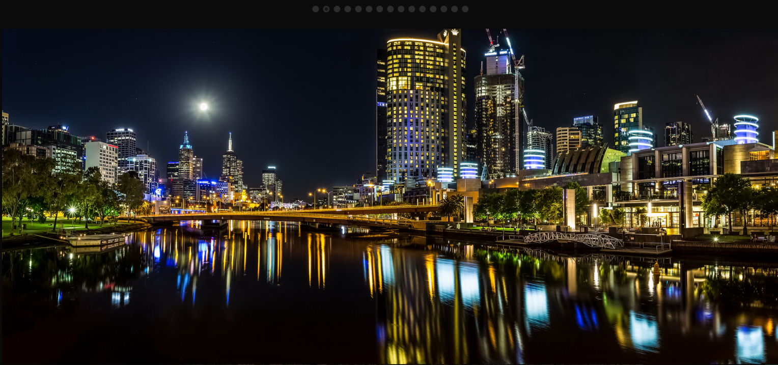
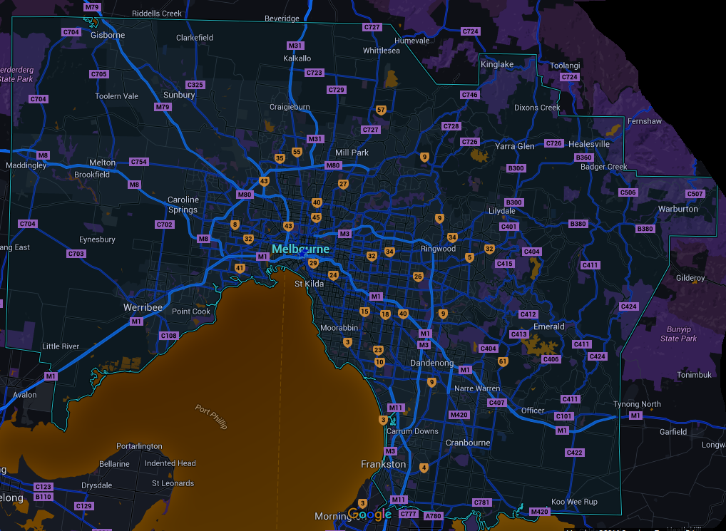
Melbourne is the capital and most populous city in the Australian state of Victoria, and the second most populous city in Australia and Oceania. The name "Melbourne" refers to the area of urban agglomeration (as well as a census statistical division) spanning 9,900 km2 (3,800 sq mi) which comprises the broader metropolitan area, as well as being the common name for its city center. The metropolis is located on the large natural bay of Port Phillip and expands into the hinterlands towards the Dandenong and Macedon mountain ranges, Mornington Peninsula and Yarra Valley. Melbourne consists of 31 municipalities. It has a population of 4,347,955 as of 2013, and its inhabitants are called Melburnians.
City Device
Climate
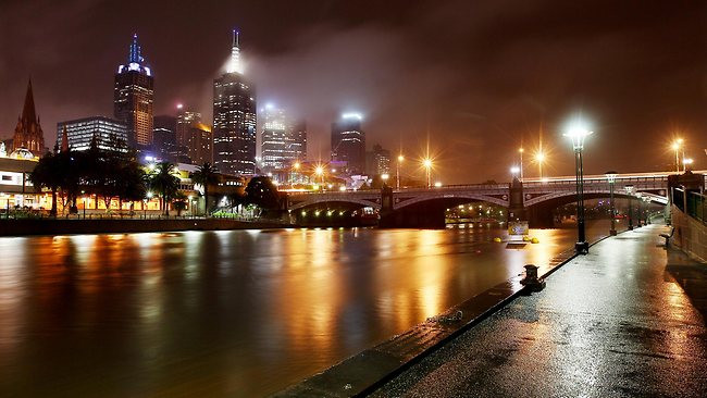
Melbourne has a temperate oceanic climate and is well known for its changeable weather conditions. This is mainly due to Melbourne's geographical location. This temperature differential is most pronounced in the spring and summer months and can cause strong cold fronts to form. These cold fronts can be responsible for all sorts of severe weather from gales to severe thunderstorms and hail, minor temperature drops, and heavy rain.
Overview
Port Phillip is often warmer than the surrounding oceans and/or the land mass, particularly in spring and autumn; this can set up a "bay effect" similar to the "lake effect" seen in colder climates where showers are intensified leeward of the bay. Relatively narrow streams of heavy showers can often affect the same places (usually the eastern suburbs) for an extended period, while the rest of Melbourne and surrounds stays dry. Overall, Melbourne is, owing to the rain shadow of the Otway Ranges, nonetheless drier than average for southern Victoria. Within the city and surrounds, however, rainfall varies widely, from around 425 millimetres (17 in) at Little River to 1,250 millimetres (49 in) on the eastern fringe at Gembrook.
Despite its relative dryness, Melbourne has 139 days of rain per year on the 0.2mm threshold, meaning that its precipitation falls as drizzle or in light rain form, which frequently occur in the winter months, rather than heavy downpours (such as those generally experienced in Sydney, Brisbane and Perth). Also, it receives only 48.6 clear days annually, making it the cloudiest capital city in Australia, and it has 180 overcast days annually, with 54 more cloudy days than Queenscliff to the south of the city, and 19 more than Mount Buller to the north. In comparison, Brisbane has 42 cloudy days annually, Sydney 134 and Hobart 174. According to the Bureau of Meteorology senior forecaster, Terry Ryan, the excess cloud over is caused by a meteorological phenomena known as "anticyclonic gloom", where high-pressure systems in winter to the city's north and west conjure a layer of warm air at a high altitude, which hold moisture from Bass Strait. The cloudiest month in Melbourne is May, with an average of 18 cloudy days, followed by July, June and August.
Melbourne is also prone to isolated convective showers forming when a cold pool crosses the state, especially if there is considerable daytime heating. These showers are often heavy and can contain hail and squalls and significant drops in temperature, but they pass through very quickly at times with a rapid clearing trend to sunny and relatively calm weather and the temperature rising back to what it was before the shower. This often occurs in the space of minutes and can be repeated many times in a day, giving Melbourne a reputation for having "four seasons in one day", a phrase that is part of a local popular culture and familiar to many visitors to the city. Dewpoint temperatures in the summer range from 9.5 °C (49.1 °F) to 11.7 °C (53.1 °F). The city experiences little humidity in summer, except at the end of hot spells following thunderstorms and rain.
Recorded extremes (From Melbourne Regional Office)
   Hottest temperature: 46.4 °C (115.5 °F), 7 February 2009
   Coldest temperature: −2.8 °C (27.0 °F), 21 July 1869
   Hottest Minimum: 30.5 °C (86.9 °F), 1 February 1902
   Coldest Maximum: 4.4 °C (39.9 °F), 4 July 1901
   Wettest month: 238.2 mm (9.38 in), February 1972
   Wettest 24 hours: 113.4 mm (4.46 in), 3 February 2005
Summer
Melbourne summers are notable for occasional days of extreme heat, which have increased in frequency since 2005. This occurs when the synoptic pattern is conducive to the transportation of very hot air from central Australia over to the south-east corner of the continent. The inland deserts of Australia are amongst the hottest areas on earth, particularly the inland parts of north-west Australia.
Every summer, intense heat builds starting in the Pilbara district of Western Australia around October/November and spreading widely over the tropical and subtropical inland parts of the continent by January. In the summer months, the southern part of the continent straddles the westerly wind belt to the south and the subtropical high-pressure ridge to the north. The intense heat buildup occurs where high pressure is highly dominant in the upper levels of the atmosphere over the tropics and subtropics of Australia in summer allowing for a huge area of stable atmospheric conditions to predominate.
On occasion, a strong cold front will develop in summer and bring the westerlies further north than their mean summer position. On these occasions, north-west winds will develop ahead of the cold front's passage and sometimes these can be very strong, even gale force. When this occurs the hot air from the inland is dragged right down over south-east Australia, occasionally even as far as southern Tasmania.
As this air mass is carried entirely over the continental land mass it remains unmodified, i.e. it does not pick up additional moisture from a body of water and retains most if not all of its heat. On these occasions, the normally temperate parts of southern Victoria, including Melbourne, can experience the full fury of the desert climate albeit only briefly as the cold front responsible usually passes through relatively quickly afterwards allowing cool southerly winds from the southern ocean to replace the hot desert air. The highest temperature recorded in Melbourne city was 46.4 °C (115.5 °F), on 7 February 2009.
Winter
Winters in Melbourne are cool with moderate rainfall. The lowest temperature on record is −2.8 °C (27.0 °F), on 21 July 1869. Snowfall is very rare: the most recent occurrence of snow in the Central Business District was on 25 June 1986 and the most recent snowfalls in the outer eastern suburbs and Mount Dandenong were on 11 August 2019. More commonly, Melbourne experiences frosts and fog in winter.
Districts
Demonym
Economy
Geography
Melbourne is located in the south-eastern part of mainland Australia, within the state of Victoria. Geologically, it is built on the confluence of Quaternary lava flows to the west, Silurian mudstones to the east, and Holocene sand accumulation to the southeast along Port Phillip. The southeastern suburbs are situated on the Selwyn fault which transects Mount Martha and Cranbourne.
Melbourne extends along the Yarra River towards the Yarra Valley and the Dandenong Ranges to the east. It extends northward through the undulating bushland valleys of the Yarra's tributaries—Moonee Ponds Creek (toward Tullamarine Airport), Merri Creek, Darebin Creek and Plenty River—to the outer suburban growth corridors of Craigieburn and Whittlesea.
The city reaches south-east through Dandenong to the growth corridor of Pakenham towards West Gippsland, and southward through the Dandenong Creek valley, the Mornington Peninsula and the city of Frankston taking in the peaks of Olivers Hill, Mount Martha and Arthurs Seat, extending along the shores of Port Phillip as a single conurbation to reach the exclusive suburb of Portsea and Point Nepean. In the west, it extends along the Maribyrnong River and its tributaries north towards Sunbury and the foothills of the Macedon Ranges, and along the flat volcanic plain country towards Melton in the west, Werribee at the foothills of the You Yangs granite ridge south west of the CBD. The Little River, and the township of the same name, marks the border between Melbourne and neighbouring Geelong city.
Melbourne's major bayside beaches are located in the various suburbs along the shores of Port Phillip Bay, in areas like Port Melbourne, Albert Park, St Kilda, Elwood, Brighton, Sandringham, Mentone, Frankston, Altona, Williamstown and Werribee South. The nearest surf beaches are located 85 kilometres (53 mi) south-east of the Melbourne CBD in the back-beaches of Rye, Sorrento and Portsea.
- Maribyrnyong River
- Yara River
- Fishermans Bend, Melbourne
Government
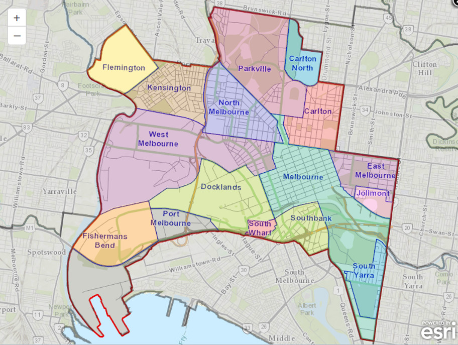
The governance of Melbourne is split between the government of Victoria and the 26 cities and five shires which comprise the metropolitan area. There is no ceremonial or political head of Melbourne; however, the Lord Mayor of the City of Melbourne often fulfills such a role as a first among equals, particularly when interstate or overseas.
The local councils are responsible for providing the functions set out in the Local Government Act 1989[183] such as urban planning and waste management. Most other government services are provided or regulated by the Victorian state government, which governs from Parliament House in Spring Street. These include services which are associated with local government in other countries and include public transport, main roads, traffic control, policing, education above preschool level, health and planning of major infrastructure projects. The state government retains the right to override certain local government decisions, including urban planning, and Melburnian issues often feature prominently in state election.
History
Population
- -- City (6.8 Million) - 2040 census
- -- Urban (14.2 Million) - Dated census
- -- Metro Area (19 million) - Dated census
Arcades
- -- Campbell Arcade
- -- Royal Arcade
Arenas
Attractions
Bars and Clubs
- -- 1806 the Bar -- City-Center, Melbourne
- -- Fathers Office -- City-Center, Melbourne
- -- Madam Brussels
- -- New Guernica
- -- The Toff In Town
- -- The Hi Fi = Matts House of Music
- -- The Bohemia Cabaret Club
- -- [[]]
- -- [[]]
- -- [[]]
- -- [[]]
- -- [[]]
- -- [[]]
- -- [[]]
- -- [[]]
- -- [[]]
- -- [[]]
- -- [[]]
- -- [[]]
- -- [[]]
Cemeteries
City Government
Crime
Melbourne has been known as the organised crime 'capital' in Australia over the decades, with high profile gangland and underworld figures and events taking place.
Asian Gangs
- -- 5T
- -- The Four Aces
- -- Madonna's Mob
European Networks
- -- The Carlton Crew -- The Carlton Crew is an Italian-Australian criminal organisation from Melbourne, Victoria. It was formed in the late 1970s by gangster Alphonse Gangitano and named after the Melbourne suburb in which it is based. The organisation had a strong rivalry with the Honoured Society and the Calabrese Family, both of which were Calabrian 'Ndrangheta groups also based in Melbourne. The Carlton Crew had a strong role in the infamous Melbourne gangland killings.
- -- Bandido
The Rest
Citizens of the City
Current Events
Fortifications
- -- Old Melbourne Gaol -- City Center
Galleries
- -- Kirra Gallery -- The Atrium, Federation Square
Holy Ground
Hospitals
- -- The Royal Melbourne Hospital
- -- Dandenong Hospital
- -- Epworth Freemasons Medical Centre
- -- St Vincent's Private Hospital, Melbourne (East Melbourne)
- -- Epworth Cliveden
- -- The Royal Victorian Eye and Ear Hospital
- -- Melbourne Eastern Private Hospital
- -- Northern Hospital
- -- Monash Children's Hospital Clayton
- -- Mercy Hospital For Women
- -- The Royal Melbourne Hospital - Royal Park Campus
Morgues
Former Williamstown Morgue
Shotton ParMED
Hotels & Hostels
Landmarks
- The Block Arcade
- The Royal Arcade
Maps
Mass Media
Three daily newspapers serve Melbourne: the Herald Sun (tabloid), The Age (formerly broadsheet, now compact) and The Australian (national broadsheet). Six free-to-air television stations service Greater Melbourne and Geelong: ABC Victoria, (ABV), SBS Victoria (SBS), Seven Melbourne (HSV), Nine Melbourne (GTV), Ten Melbourne (ATV), C31 Melbourne (MGV) – community television. Each station (excluding C31) broadcasts a primary channel and several multichannels. C31 is only broadcast from the transmitters at Mount Dandenong and South Yarra. Hybrid digital/print media companies such as Broadsheet and ThreeThousand are based in and primarily serve Melbourne.
Monuments
Museums
- -- The Chinese Museum
- -- The Hellenic Museum
- -- Melbourne Museum
Neighborhoods of the City
At more than 7,695 sq. km (2,971 sq. miles), Melbourne is one of the biggest cities in the world by area, with a population of about 3.5 million. Following are the neighborhoods of most interest to visitors.
- Abbotsford
- Fitzroy -- A ruggedly bohemian place 2 km (1 1/4 miles) north of the city center, Fitzroy is raw and funky, filled with students and artists and popular for people-watching. Fitzroy revolves around Brunswick Street, with its cheap restaurants, busy cafes, late-night bookshops, art galleries, and pubs. Around the corner, on Johnston Street, is a growing Spanish quarter with tapas bars, flamenco restaurants, and Spanish clubs. Tram: 11 from Collins Street.
- Newport
- Richmond -- One of Melbourne’s earliest settlements is a multicultural quarter noted for its historic streets and back lanes. Victoria Street is reminiscent of Ho Chi Minh City, with Vietnamese sights, sounds, aromas, and restaurants everywhere. Bridge Road is a discount-fashion precinct. Tram: 48 or 75 from Flinders Street to Bridge Road; 70 from Batman Avenue at Princes Bridge to Swan Street; 109 from Bourke Street to Victoria Street.
- South Kingsville
- Southgate & Southbank -- This flashy entertainment district on the banks of the Yarra River opposite Flinders Street station (linked by pedestrian bridges) is home to the Crown Casino, Australia’s largest gaming venue. Southbank has a myriad of restaurants, bars, cafes, nightclubs, cinemas, and designer shops. On the city side of the river is the Melbourne Aquarium. All are a 10-minute stroll from Flinders Street Station. Tram: 8 from Swanston Street.
- Spotswood
- South Yarra/Prahran -- This posh part of town abounds with boutiques, cinemas, nightclubs, and galleries. Chapel Street is famous for its upscale eateries and designer-fash1ion houses, while Commercial Road is popular with the gay and lesbian community. Off Chapel Street in Prahran is Greville Street, a bohemian enclave of retro boutiques and music outlets. Every Sunday from noon to 5pm, the Greville Street Market offers arts, crafts, old clothes, and jewelry. Tram: 8 or 72 from Swanston Street.
- South Melbourne -- One of the city’s oldest working-class districts, South Melbourne is known for its historic buildings, old-fashioned pubs and hotels, and markets. Tram: 12 from Collins Street; 1 from Swanston Street.
- Toorak
- The River District -- The muddy-looking Yarra River runs southeast past the Royal Botanic Gardens and near other attractions such as the Arts Centre, the National Gallery of Victoria, the Sidney Myer Music Bowl, the Melbourne Cricket Ground, and Birrarung Marr parkland. It is accessible by the free City Circle Tram.
- Williamstown --
- Williamstown North --
Parks
Private Residences
- -- Labassa
Restaurants
Ruins
Schools
- -- Royal Melbourne Institute of Technology (RMIT University)
Shopping
- -- Block Arcade
- -- Royal Arcade
Supernaturals of Melbourne
- Mages of Melbourne
- Fae of Melbourne
Supernatural Objects
- -- Masks of Dii Consentes -- Four of these mystical masks have appeared in the city during the month of December - 2042.
Telecommunications
Theaters
Transportation
Airports
- -- Melbourne Airport (Tullamarine)
- -- Avalon
- -- Avalon Airport
- -- Essendon
- -- Moorabbin
Auto Travel (Roads)
- -- M1 -- From Melbourne to Werribee, Geelong (South West), Melbourne to Dandenong, Dar Dar Goon (South East)
- -- M3 -- From Melbourne to Frankston (South South East),
- -- M8 -- From Melbourne to Ballarat, points North West
- -- M31 -- From Melbourne to Sydney
- -- M79 -- From Melbourne to Ravenswood South (North North West)
Railroad Lines
Public Transportation
Shipping Lines
Vampires of the City
Brujah
- -- Antonio Romano -- Enforcer
- -- Conrad Schrek -- Controls the Police Force
- -- Fenris (Brujah) -- Enforcer
- -- Joyce "Willie" Scott -- Queen of Prostitution
- -- Larson Moore -- King of the Drug Trade
- -- Mina Celestine -- Childe of Larson Moore, Controller of the Airport
- -- Leslie "Squizzy" Taylor -- Prince of Melbourne
Caitif
The Tomb Boys
Followers of Set
Gangrel
- -- Lady Eliza Worthington -- Primogen
- -- Crow -- Anarch
Malkavian
Nosferatu
- -- Simone Alvarde -- Primogen
- -- Kerry Simpson -- Anarch
- -- Michelle Morgan -- Rape victim
Tremere
The chantry house is at 51 Sterling St., Melbourne.
- -- Professor Cipher -- Chantry Regent, Melbourne
- -- Natasha Karaljk Scheinberg -- Tremere prophetess
- -- Seth Dalibor Petocs -- Tremere Initiate
- -- Czere Ubireg -- Warlock guardian of the Masquerade.
- -- Dural Howell -- Ghouled Aboriginal manservant of Professor Cipher
Toreador
- -- Tien Hsu -- "Mehitabel"
- -- Maria Diamente -- Toreador Primogen
- -- Sebastian Wilde -- Childe of Sarrasine, ambassador from Sydney.
Ventrue
- -- Thorton Adams -- Ventrue Primogen
- -- Melissa Redman -- Political Animal
- -- Victoria Grant -- Late Night News caster
Sabbat of Melbourne
Mothers Hands
- -- Calliphaes -- Tremere Antitribu
- -- Galipoli -- Lasombra
- -- Herman Polaski Malkavian Antitribu
- -- Naomi McKeller -- Ventrue Antitribu
Elysium
- -- Royal Arcade
- -- Trades Hall
Visitors to the City
- -- Frederick Coughlin Tremere from Houston
- -- Vampiric Protege to Frederick, Nataly Agema, research assistant.
Websites
https://en.wikipedia.org/wiki/Melbourne
http://www.melbourne.vic.gov.au/Pages/Home.aspx
http://www.weekendnotes.com/spookiest-urban-legends-melbourne/ {Very much worth a read!}
http://www.emelbourne.net.au/index.html
https://www.pinterest.com/mrstoomie/i-love-melbourne/
http://www.visualresource.com.au/modern-collection/melbourne-collection-1
http://www.visualresource.com.au/modern-collection/melbourne-collection-2
